We are lucky to have the chalk downland supply 70% of our drinking water in Sussex. We all rely upon this supply and for some businesses such as Harveys, the quality of water is of paramount importance.
Water, water everywhere flowing in different ways
Water cycles forever. It is possible that you have drunk the same water that a dinosaur once sipped! Water based ecosystems are around us in lots of forms and are interconnected.
As well as the river, you can find springs, a knucker hole, marshes, water meadows and dry valleys under which water still flows. Lewes arose due to water because it is situated at a gap in the Downs created by the River Ouse. It was a good place to cross the river and navigable at this point, facilitating transport. (The Ouse was navigable up to Isfield before its canalising in the early 19C.) You can also find water features we create for our benefit, including dew ponds and rain gardens.
Floods
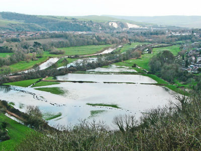
Lewes is susceptible to flooding in part because the River Ouse encounters a bottleneck in the middle of town through which all the water in the catchment flows. The river is also tidal so it is prone to flood during a high tide combined with stormy weather. Understanding and working with natural ecosystems allows us to manage this risk effectively. There are water meadows and wetlands on the floodplain alongside the River Ouse upstream and downstream of Lewes. They naturally store flood water, reducing flood risk in Lewes
Let’s value water more
Sometimes we expect too much of our watery ecosystems. We want protection from flooding but build more homes on the floodplain reducing the floodwater storage of these areas, which can exacerbate local flooding. We can help in simple ways such as considering our water usage, having water butts and making use of permeable surfaces instead of hard paving.
Chalk aquifers
Chalk is one of the rarest geologies in the world but we have a large chunk of it in Sussex in the form of the South Downs. The rainwater which falls on the Downs is filtered through the chalk, which acts like a big sponge.
Beneath the Downs it forms natural underground reservoirs called aquifers, eventually emerging (maybe more than 100 years later) as clean, pure springs of water that flow and even pop up in Pells pool. Just think about what is happening under your feet!

Water quality
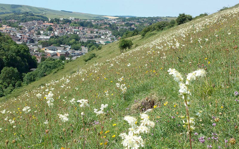
How does the beautiful and endangered Adonis Blue butterfly help provide high quality beer? Harvey’s Brewery has a strong connection with the local environment – using water from its own artesian well, filtered through the local chalk. The type of vegetation and land management on the Downs makes all the difference to the quality, quantity and reliability of supply of water. Chalk grassland that is managed for the benefit of species such as the Adonis Blue butterfly can support as many as 50 different species of plants in one square metre, capturing and aiding the infiltration of rainwater, reducing run-off that can cause flooding, also lowering the risk of pollutants reaching our water supply.
Dry valleys
Dry valleys in our chalk landscape originate from the ice ages when freezing conditions prevented water filtering into the ground. During ice age summers, fast-flowing surface meltwater streams carved gentle valleys on their passage downhill.
An example within Lewes town runs through the Paddock where now invisible water still flows below the surface. This lovely landscape feature connects the downs with the river and could act as a wildlife corridor if we wanted.
Chalk stream
The Winterbourne is a rare and special feature that runs through Lewes. It is a seasonal chalk stream that connects the downs with the river having emerged from a spring at the foot of the hills. There are approx 210 chalk streams in the world with 85% here in south and south-east England. Due to the filtering effect of the chalk its waters are alkaline and clear.
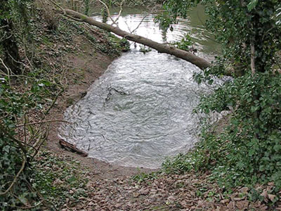
Knucker holes are strong chalk springs. The water may have been filtering down through the chalk from rain that fell long ago. Knucker holes retain a constant temperature through the seasons. Beware though, knucker is a word from Saxon times associated with water dragons!
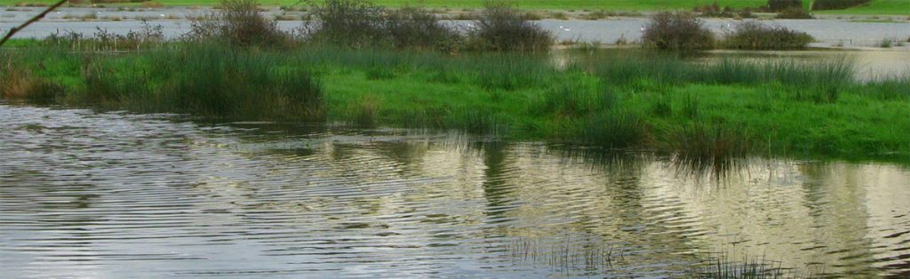
Wetlands
Healthy wetlands are vital for both society and wildlife. They can help to reduce flood risk downstream, improve water quality, support biodiversity by providing crucial habitat for a wide variety of aquatic, semi-aquatic and terrestrial species, help to improve air quality, contribute to regulating the climate, and provide important recreational areas.
Wetlands are important but threatened habitats, with at least 80% of Sussex wetlands estimated to have been damaged or destroyed, often by digging ditches and draining the areas to improve accessibility and/or agricultural productivity.
In many places rivers have been confined to their channels by deepening and straightening them, and by building embankments. Whilst this may be necessary in areas where people have built alongside watercourses, in other areas, if the river can be reconnected to its floodplain as it would naturally be, huge volumes of water can be temporarily stored during flood events, benefiting communities downstream by reducing the impacts of flooding to properties and other infrastructure. Restoring the connection between a river and its floodplain can also begin to encourage the formation or restoration of degraded wetlands.
The Pells wetland is connected to the Downs via the chalk springs and the chalk aquifer. This little area provides flood protection by acting as a sponge and is a lovely example of how floodplain areas could be left in a more natural state, benefiting wildlife as well as us.
Marshes such as Offham Marshes just north of Lewes are rich habitats for wildlife and naturally contribute to flood management.
Riverside woodland

Floodplain woodlands are amongst the most natural and dynamic woodland systems and can slow down and clean floodwater, contributing to flood alleviation. Now-rare species such as the Otter depend on this scarce habitat. It is the natural home of the Black Poplar, the most endangered native timber tree in Britain, ancient examples of which remain just north of Lewes town and a small plantation just south of the town in The Lewes Railway Land.
Reedbeds
Reedbeds naturally filter water, protect from erosion and are great wildlife habitats. Chris Drury, a local but internationally famous environmental artist, worked alongside ecologists to create an ecologically rich artwork of reedbeds (now home to specialist species such as Reed Warblers) in the pattern of a double vortex, representing the flow of blood through the heart and creating a lovely space to walk and contemplate in the heart of Lewes.
Dew ponds
Dewponds are shallow clay-lined pits created by people on the Downs where there is no surface water, to provide sheep and cattle livestock with water to drink. They attract many types of wildlife.
Rain gardens and Sustainable Urban Drainage Systems (SUDS)
Rain gardens are designed to be attractive features that provide localised flood control, reduce water loss into drains and out to sea, instead helping to recharge our groundwater. There is a specially built planter built to take water from Southover Church roof and plans are afoot to create rain gardens to reduce flooding of several roads in Lewes. Special beneficiaries of Lewes water
Harveys
Pells Pool
All of us!
Natural Flood Management in the River Ouse
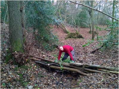
Natural Flood Management (NFM) is a way of reducing flooding that works with natural processes rather than against them. It offers a range of different techniques to help slow and store water upstream, in order to reduce flooding downstream, and also supports a multitude of other ecosystem services.
Over the last 100 years, our landscape has been extensively drained for agriculture and engineered to channel water into the river and out to sea as quickly as possible. Floodplain woodlands were cleared to access the nutrient-rich soils for farming. A large network of drainage ditches, combined with a dredged and deepened river channel, means that under extreme rainfall we see a rapid rise and fall in water levels, creating a large flood surge with devastating results for communities downstream. This historic management has also led to a degradation of our rivers and streams, with uniform deep-sided channels that lack many of the natural features and habitats important for river health, like bankside vegetation and in-channel wood.
By restoring the ability of the land to slow and store water, rainfall is once again able to slowly drain into streams, or percolate deeper into soils and replenish groundwater stores.
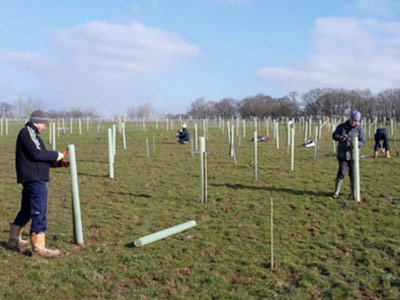
The Sussex Flow Initiative (SFI) is an NFM project focused on reducing flood risk in Lewes and other nearby towns and villages. Since they began in 2012, with the help of local volunteers, they have planted over 57,000 trees in the form of 8.9 km of new hedgerow and 8.3 ha of woodland, including 4.2 ha of floodplain woodland & 125 rare Black Poplars. Trees can help to reduce flooding by intercepting rainfall, taking up water from the soil, slowing down surface run-off and floodwater, and promoting water infiltration and percolation into soil and groundwater. These processes hold water on land, and reduce the amount and speed of the delivery of water to our streams and rivers. The Sussex Flow Initiative has also created over 3,250,000 litres of new, seasonal water storage, including a flood storage pond, wader scrapes and a washland which can be activated in every rainfall event.
SFI works with landowners, local people and others to investigate, promote and create natural features designed to slow and store water in the landscape. They aim to deliver multiple benefits for people and wildlife, and show how NFM can be used to support traditional flood management methods to help reduce flooding.
For more information on Natural Flood Management and the Sussex Flow Initiative, please visit www.sussexflowinitiative.org
Ouse and Uck – sketch of a Sussex catchment
Booklet by Hew Prendergast, with all profits going to OARTS
With a background to the historical role of the Ouse and Uck, this booklet describes current issues and sets out some of the activities underway to solve them.
Cost: £7 (including p&p) For a copy please contact hew.prendergast@oart.org.uk
For more information on Ouse & Adur Rivers Trust please visit:
https://oart.org.uk/rivers/sussex-ouse